
Maps are a revolutionary way of exploring and examining the world. However, due to technological enhancements and political alignments maps can also be a brilliant way to deceitfully push a political agenda rather then lead a person to a place, in which a map historically operates as its main function. This critical response will discuss arguments of the question ‘are maps political?’ in both for and against backed up through the use of academic sources, visuals and examples which will in turn solve the answer to this question to show that maps are indeed political.
What is the definition of political? Political relates to the public affairs and governance of a country.
This quote below examines how maps are truly seen in the world, and how there are so many diverse languages around the world, there are many views around the world that shape the politics of the world.
Maps are a language, and give us a view on the world. (Henderson, G & Waterstone, M, 2009, Geographic Thought: A Praxis Perspective, Routledge, New York).
G. Henderson and M. Waterstone.
Perplexed
Maps are a tricky piece to navigate. This is where political perspective comes into play and can really discuss whether maps are political or not, based on what viewpoint is being examined. A key example is the country Cyprus, how a nation, can be divided into two and depending on what ‘ political perspective’ that is given, this map can be spreading a political agenda. The politics of a map is perplexed in a country like Cyprus as international governance has still yet to decipher the true politics of the island. Ultimately, the map further drives the political perspective of both sides as there are Greek and Turkish political agendas being displayed.
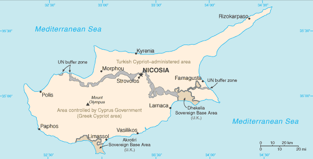
This map can be seen as political for both sides of the island, for Turkey, with a view of Turkish Cypriot-administered area rather than the self proclaimed ‘Turkish Republic of Northern Cyprus’, whereas for the Cypriot Greeks the whole map is a looks political. The occupation remains illegal to this day, and their perspective shows the map is political by simply having a Turkish Cypriot administered area.
For more clarity and understanding, this video goes into great depth on the Cyprus Dispute.
Maps are political, a person identifies with where they are on a map which can lead to a wide range of politics. What Y. Papadakis, N. Peristianis and G. Welz (Papadakis, Y, Peristianis, N & Welz, G, 2006, Divided Cyprus: Modernity, History, and an Island in Conflict, Indiana University Press, Indiana. ) discuss as a ‘hellenic identity’ is really the spark of the perspective which leads to the primary political perspective on the island, enhanced through the map that is present. A political identity also comes with the place on the map the person is from, this ‘hellenic’ identity is corroborated with the ‘Turkish Cypriot identity’ that also steps on the island. So-that, upon the issue of perspective, a map will always be political as two different perspectives and political alignments clash to find the true ‘meaning’ of the map. This true meaning of a map showing a place can be hidden, as a political perspective of people will look at the map, thus being told to identify this politics rather than on country as a whole. All in all, a map will always show a political perspective and identity will lead to maps always being political all over the world, specifically if there is conflict in set place.
That Exists?!?!
Electronic have revolutionised as new technology has enhanced throughout the years. Since 2012, Google Maps has displayed 5 million miles and collated 20 petabytes of images. However, as this below image shows, this map is not political but rather a lack of resources in set countries through the ‘Street View’ feature on Google Maps.

There are different parameters into why these nations do not have street view, including, wars, barren roads and licensing this graphic alone. However, the nations that do not have ‘Street View’ can be seen, interpreted and displayed however by the following nations through politics. Especially if the politics are not aligned with a neighbouring country, e.g. Communism v Democracy. Ultimately, this example shows how ‘street view’ is not in itself political, however, someone will look at a map and gain a political perspective on the set place based on what they have been taught. This shows the negative side of the political maps argument, as it is not the maps themselves, but the political alignments of set people.
Wrapping It All Up
Conclusively, maps are ALWAYS political. Maps are dependent on interpretation, identity and representation of the nation being seen, which will always be interpreted through a political alignment and view. These politics are all altered and different depending on the persons pre-conceived notions of a certain place. This means that there is no definitive definition of a place as every person thinks differently of nations, especially if the nation itself has a confusing element to it like Cyprus. These thoughts are corroborated through politics, in which maps help to push. Therefore, whilst maps are useful in seeing the world, community and places, they are political as maps fail to display full transparency of all political alignments and depict one set view of a place around the world. Contrastingly, maps also show places on a map and people will always interpret the map based on politics regardless on if a map is there or not. Conclusively, maps will always be political as identity and political perspectives remain stagnant throughout generation to generation, which can also be bolstered through set maps around the world. Different maps will be shown around the world based on a certain political perspective regardless of whether the map company wants to remain ‘neutral’.
Bibliography
Geography IQ, World Atlas- Middle East- Map of Cyprus, Geography IQ, accessed 26th March 2022, https://www.geographyiq.com/countries/cy/Cyprus_map_flag_geography.htm
Henderson, G & Waterstone, M, 2009, Geographic Thought: A Praxis Perspective, Routledge, New York.
Nations Online Project, Map of Australia, Nations Online Project, accessed 26th March 2022, https://www.nationsonline.org/oneworld/map/australia-map.htm
Papadakis, Y, Peristianis, N & Welz, G, 2006, Divided Cyprus: Modernity, History, and an Island in Conflict, Indiana University Press, Indiana.
Statista, 2017, Chart: Which Countries Have Google Street View?, viewed 26th March 2022, https://www.statista.com/chart/11778/which-countries-have-google-street-view/
WonderWhy, 2018, The Unsinkable Aircraft Carrier: Cyprus Dispute Explained, online video, viewed 26th March 2022, https://youtu.be/WHlHnCwFp5c
